Indian Ocean Tsunami Fuels Completion of NOAA Tsunami Warning System
By Lauren Koellermeier
PMEL Outreach Coordinator
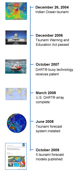 |
| Time line: Click to enlarge for more detail |
On Dec. 26, 2004, more than 230,000 people lost their lives in the deadliest tsunami in history. The lack of any warning system or proper education was evident as people were caught by surprise when tsunami waves flooded coastlines around the Indian Ocean basin.
Five years later, U.S. and international coastlines are far better prepared for such a catastrophe thanks in part to research by the NOAA Center for Tsunami Research at Pacific Marine Environmental Laboratory (PMEL) in Seattle, Washington.
Today, if an earthquake triggered a tsunami threatening Indian Ocean, Pacific Rim and Caribbean nations, the NOAA tsunami warning centers in Alaska and Hawaii could issue warnings within minutes of the earthquake.
Tsunami Buoys Positioned to Protect the U.S. Coastline
Scientists at PMEL and the NOAA-funded Joint Institute for the Study of the Atmosphere and Ocean at the University of Washington have been researching tsunamis for more than 40 years. Engineering and scientific achievements—especially following the 2004 Indian Ocean tsunami—have allowed PMEL and NOAA to play an important role in international tsunami warning and education.
In 2008, NOAA deployed the final two Deep-ocean Assessment and Reporting of Tsunami (DART®) tsunami detection buoys in the South Pacific, completing the U.S. array of 39 stations. Prior to the 2004 tsunami only six buoys were in place. DART® buoys were developed at PMEL and can measure a tsunami wave as small as 1 centimeter in the open ocean and provide these data in real-time to forecast when a wave may hit the coast and how high it will be. The operation of the DART® buoy array was transferred to the National Weather Service National Buoy Data Center who now maintains the network.
"Since 2003, DART® data have been used 15 times in producing tsunami forecasts. When comparing forecast with tide gauge data, we see 80 percent accuracy. We are very proud of the performance of the system," says Eddie Bernard, Ph.D., director of PMEL, who led the DART® development team.
Furthermore, in 2007 PMEL received its first patent for the DART® buoy technology and also transferred the technology to SAIC who now builds and sells DART® buoys.
Australia, Chile, Indonesia and Thailand also have deployed DART® buoys as part of their tsunami warning systems. The DART® buoys are a crucial part to the new international system that enables quick and accurate warnings. The other part is improved tsunami forecast models.
Advanced Forecast System Models at the Community Level
Since 1997, PMEL tsunami scientist Vasily Titov and his team have been working on a new system for faster and more accurate forecasts of approaching tsunamis. NOAA's research and ability to forecast tsunamis has greatly improved since the 2004 tsunami.
"In 2004, NOAA had no operational inundation forecast models. Today we have 43 site-specific forecast models, that are used by Tsunami Warning Centers to produce real-time high-resolution tsunami forecast for threatened communities," Titov said.
These inundation forecast models incorporate local topography and historical tsunami data in order to more accurately predict exactly how a wave might behave when it hits the shore. Before these models, scientists could only predict arrival time, not inundation potential PMEL will create a total of 75 site-specific inundation models that include beachside communities on the east and west coasts, including Alaska, Hawaii, American Samoa, U.S. Territories, Puerto Rico and U.S. Virgin Islands. Reports are being prepared for the 75 models under development with the first five already published that include Hilo, Hawaii; Kodiak, Alaska; Newport, Ore.; San Francisco; and Crescent City, Calif.
"Only by combining DART® observations with high-resolution site-specific forecast models can the forecast provide the accuracy required for efficient warning and mitigation during the tsunami event", Titov said.
Tsunami Warning System
The new forecast system, which includes DART® buoys and forecast models, was installed at the National Weather Service tsunami warning centers in Hawaii and Alaska in June 2009 and is now in test operation.
On Sept. 29, 2009, when an 8.0 earthquake triggered a tsunami near Samoa, a well-educated public and early warning system saved lives in Samoa and prevented unnecessary evacuations in Hawaii. A similar event in 1994 caused by an 8.1 magnitude earthquake off Russia's Kuril Islands triggered a mass evacuation of Hawaiian coastal communities only to be followed by very small, un-destructive tsunami wave.
NCTR will continue to move forward to the next generation of tsunami forecasting by refining their forecasting models and techniques and creating new buoy deployment packages like the Easy-to-Deploy (ETD) buoy designed by engineers at PMEL. The progress over the last 5 years is proof that the United States and World are be better prepared should an event like the 2004 tsunami happen in the future.