U.S. Coastline Tsunami Hazard Assessment
for the Nuclear Regulatory Commission
Introduction:
Applications to build and operate up to 26 new nuclear power reactors are expected over the next few years, increasing the current level of 104 nuclear power reactors licensed to operate in the U.S. at 65 sites in 31 states. Some candidate Nuclear Power Plant (NPP) sites may be located on coasts subject to tsunamis hazard. The devastation to coastal infrastructure caused by the Indian Ocean tsunami of 24 December 2004 has changed the perception of a tsunami as a low-risk hazard. Tsunamis are now viewed as a hazard of medium probability and potentially high risk for world coastlines. 6 destructive tsunamis that have occurred since 2005 are convincing arguments for such assessment. The December 2004 catastrophe focused attention to sources with under-estimated tsunami potential convincing researchers to broaden list of possible danger areas (Geist et al., 2005). The Indian Ocean tsunami has also increased awareness of this hazard to the NPPs.
|
Research Objective:
This research aims to help the Nuclear Regulatory Commission (NRC) evaluating tsunami hazard for NPP sites. The plan takes into account specific safety requirements of the NRC that significantly broaden the scope of potential tsunami sources. The research will add to the current state of science in tsunami hazard assessment, which is especially limited for the East Coast and the U.S. coast of Gulf of America.
Methodology:
The tsunami science has produced a variety of research tools for tsunami hazard assessment. In particular, the tsunami modeling technology has evolved tremendously during the last 20 years, when crucial field observation and laboratory data have become available for model verifications and testing. The numerical modeling of tsunami dynamics has become a standard research tool in tsunami studies. Modeling methods have matured into a robust technology that has proven to be capable of accurate simulations of historical tsunamis, after careful consideration of field and instrumental historical data. Recently developed standards and criteria for tsunami model use in operations (Synolakis et al., 2007) provided solid ground for practical model applications. At the same time, the Sumatra tsunami of 26 December 2004 reminded that most of the world coastal communities and infrastructures are unaware and unprepared for the hazard from coastal flooding by multiple tsunami waves. This event also highlighted research challenges and triggered accelerated efforts to fill the gaps in the tsunami science.
Tsunamis generated by landslides : The first research focus area is development of a computer model to simulate landslide generated tsunamis, with arbitrary parameters and arbitrary scales, including full coupling with water column. The model will be tested comprehensively against field and laboratory data.
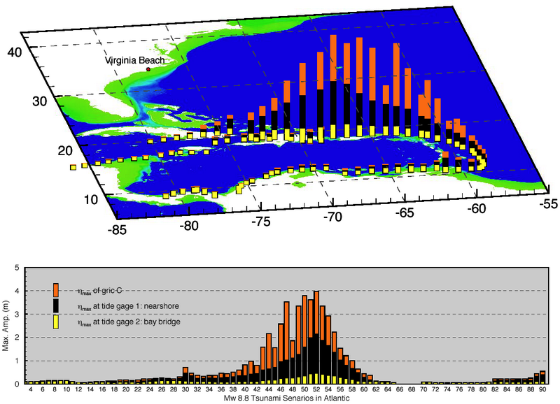
Tsunamis from seismic sources: The second research focus is regional and local tsunami hazard assessment from seismic sources, utilizing tools for tsunami hazard assessment studies in NOAA's SIFT tsunami forecast system. SIFT includes a model database of tsunami propagation scenarios which can provide detailed analysis of the tsunami potential for a coastal region or a coastal community and pinpoint high-impact sources for a given coastal location. A very comprehensive analysis is feasible because more than a thousand propagation scenarios for all major seismic tsunami source areas are readily available from the database. The scenario database will be updated with the latest findings from the U.S. Geological Survey (USGS) analysis of tsunami sources.
Case study for Probable Maximum Tsunami (PMT) analysis from seismic, landslide and impact sources: The PMT analysis will include model assessment of tsunami impact from several types of tsunami sources identified from the regional and/or local tsunami hazard assessment. The case study will use the high-resolution inundation model to assess the tsunami impact at the chosen site. The study will use the experience and recommendation from the FEMA pilot study (Tsunami Pilot Study Working Group, 2006). PMT analysis will not only provide tsunami assessment for a selected community but will have a regional tsunami hazard assessment value.
References:
Geist, E.L., V.V. Titov, and C.E. Synolakis (2006): Tsunami: Wave of change. Scientific American, 294(1), 56–63. Text of article from the Scientific American website.
Tsunami Pilot Study Working Group (2006): Seaside, Oregon Tsunami Pilot Study—Modernization of FEMA flood hazard maps. NOAA OAR Special Report, NOAA/OAR/PMEL, Seattle, WA, 83 pp. + 7 appendices.
Synolakis, C.E., E.N. Bernard, V.V. Titov, U. Kânoğlu, and F.I. González (2007): Standards, criteria, and procedures for NOAA evaluation of tsunami numerical models. NOAA Tech. Memo. OAR PMEL-135, NOAA/Pacific Marine Environmental Laboratory, Seattle, WA, 55 pp. [PDF Version]
Links: