Not an official forecast
Solomon Islands Tsunami, February 6, 2013
Main Event Page
Solomon Islands Event Page | Local Impacts | Model and Data Comparison Plots
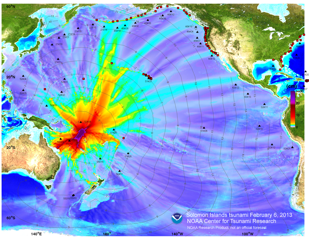
The Solomon Islands tsunami was generated by a Mw 8.0 earthquake (10.738°S 165.138°E ), at 2013-02-06 01:12:27 UTC, 76km (47mi) W of Lata, Solomon Islands (according to the USGS). In approximately 40 minutes, the tsunami was first recorded at tsunameter/DART® buoy 52406. Forecast results shown below were created with the NOAA forecast method using MOST model with the tsunami source inferred from tsunameter/DART® data.
The graphics display research forecast results, showing qualitative and quantitative information about the tsunami, including tsunami wave interaction with ocean floor bathymetric features, and neighboring coastlines. Tsunami model amplitude information is shown color-coded according the scale bar. Offshore tsunami wave amplitude was forecasted based on actual tsunami observations at DART 52406 and was not based on any particular earthquake mechanism.
Modeling Results- Model amplitudes calculated with the MOST forecast model. Filled colors show maximum computed tsunami amplitude in cm during 24 hours of wave propagation. Black contours show computed tsunami arrival time.
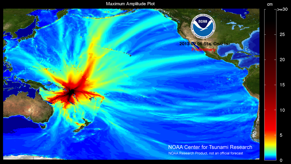
- Alternate model amplitude plot that shows lower amplitude distribution well.
- Local impacts for the island of Bairiki
 Propagation animation and .mov file.
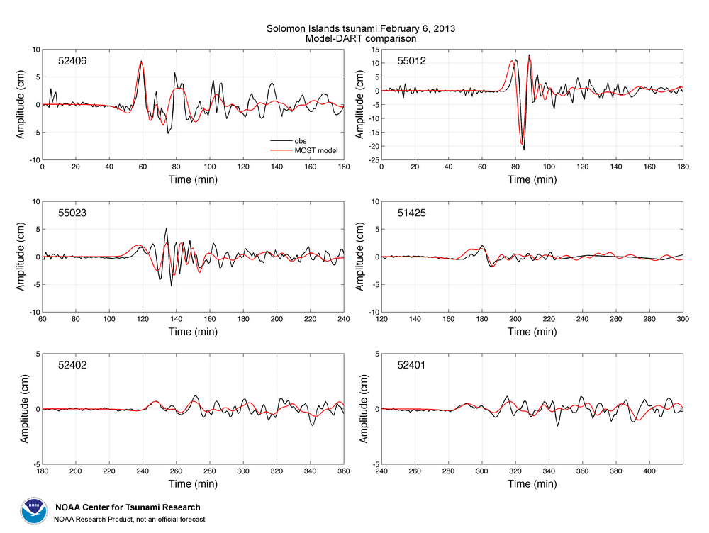
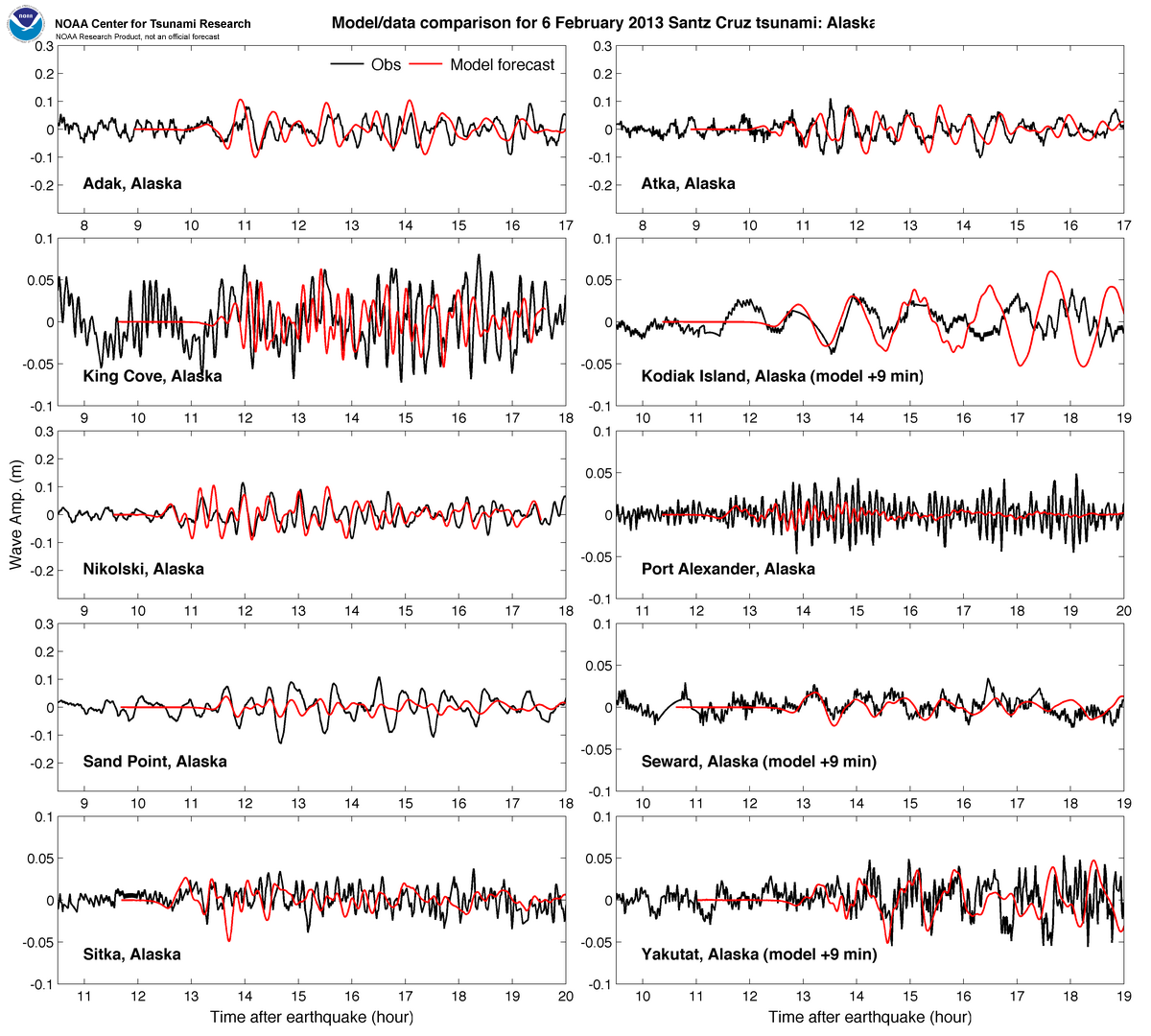
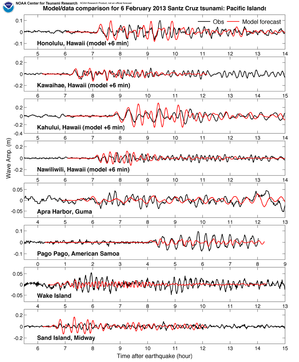
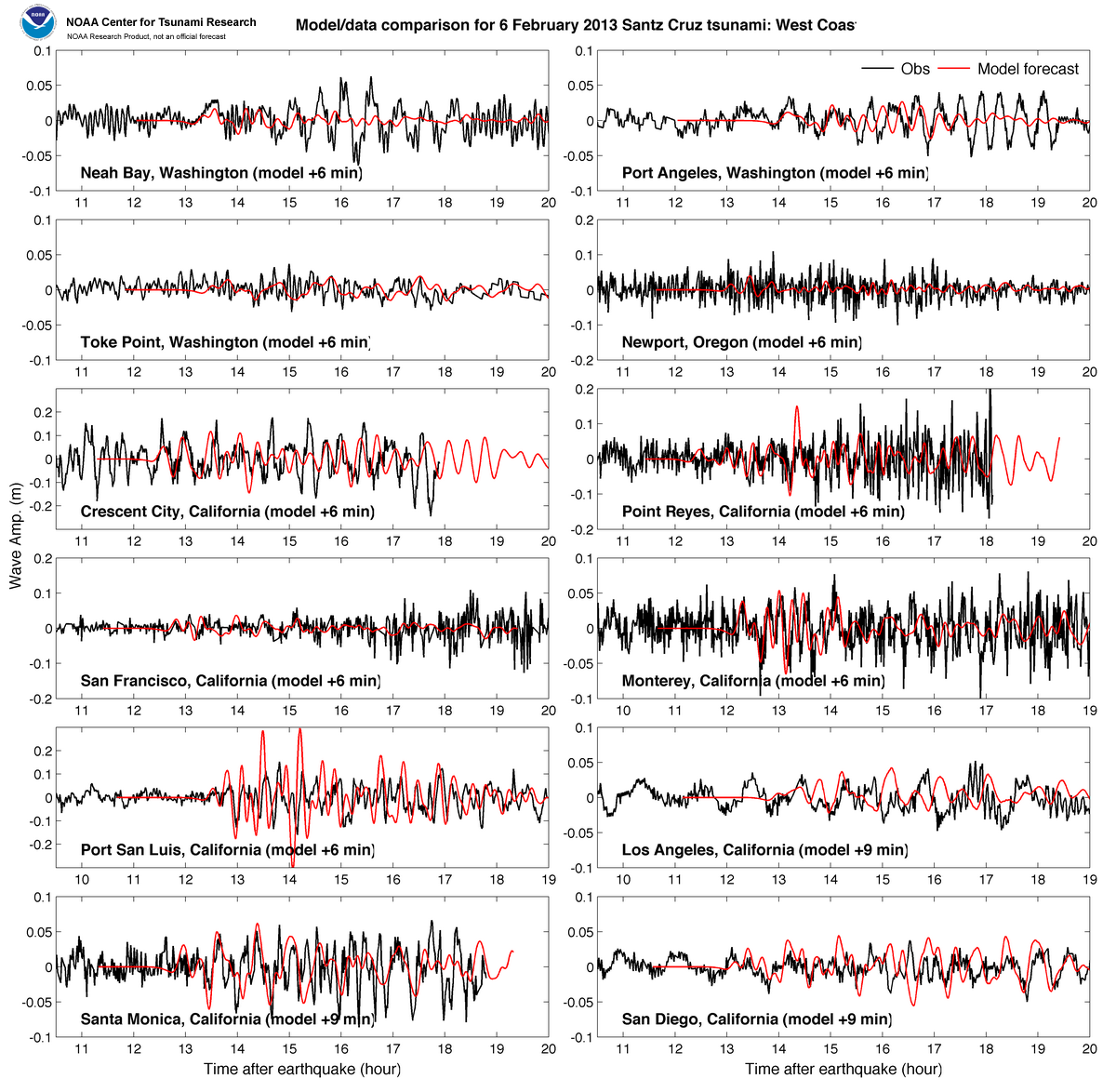
Model and tsunameter/DART® buoy data / tide gauge data comparison
Comparison of the February 6, 2013 Solomon Island tsunami recorded at tsunameter/DARTs and sea-level gauges with model forecasts. The DART model timeseries are obtained from the pre-computed generation/propagation forecast database in real time, after fitting models to tsunami records from the closest DART (52406).
- DART
- Tide Gauges
- Local impacts for the island of Bairiki
- Unit Sources: 0.41*nv21a+3.87*nv21b+5.7*nv22b
References:
Tang, L., V.V. Titov, E. Bernard, Y. Wei, C. Chamberlin, J.C. Newman, H. Mofjeld, D. Arcas, M. Eble, C. Moore, B. Uslu, C. Pells, M.C. Spillane, L.M. Wright, and E. Gica (2012): Direct energy estimation of the 2011 Japan tsunami using deep-ocean pressure measurements. J. Geophys. Res., 117, C08008, doi: 10.1029/2011JC007635
Tang, L., V. V. Titov, and C. D. Chamberlin (2009), Development, testing, and applications of site-specific tsunami inundation models for real-time forecasting, J. Geophys. Res., 114, C12025, doi:10.1029/2009JC005476. [PDF version]
Titov, V.V. (2009): Tsunami forecasting. Chapter 12 in The Sea, Volume 15: Tsunamis, Harvard University Press, Cambridge, MA and London, England, 371–400.
Wei, Y., C. Chamberlin, V.V. Titov, L. Tang, and E.N. Bernard (2012): Modeling of 2011 Japan Tsunami - lessons for near-field forecast, Pure Appl. Geophys., doi: 10.1007/s00024-012-0519-z
Wei, Y., E. Bernard, L. Tang, R. Weiss, V. Titov, C. Moore, M. Spillane, M. Hopkins, and U. Kânoğlu (2008): Real-time experimental forecast of the Peruvian tsunami of August 2007 for U.S. coastlines. Geophys. Res. Lett., 35, L04609, doi: 10.1029/2007GL032250. [PDF Version]
Disclaimer: The forecasts on these pages show the results of ongoing research to enhance tsunami science and to improve NOAA operational tsunami forecasts. These products were developed during or shortly after the tsunami event, are intended for research use, and are not an official forecast. They should not be used as the basis of any public or private policy decisions. Please contact NCTR to find if there are more detailed follow-on analysis results.
For media inquiries:
When using information from this page, please credit NOAA / PMEL / Center for Tsunami Research