Another Tsunami Wake Up Call in the Indian Ocean
|
|

Dr. Diego Arcas
NCTR Research Scientist
July, 2006
There are still many uncertainties about the earthquake and ensuing tsunami of July 17th, 2006. Preliminary reports about the event seem to describe tsunami wave heights comparable or even of larger amplitude than those observed during the tsunami generated by the March, 28th, 2005 earthquake located in the same subduction zone.
Despite similar intensity of the generated tsunamis, there is a substantial difference in earthquake magnitudes between the two events. A magnitude of 8.4 was reported for the March 2005 event, whereas a much smaller, magnitude of 7.7 has been recorded for the most recent July, 2006 event. Some researchers have indicated the possibility of an associated submarine landslide in the most recent event which would help explain the large tsunami magnitude; others are more inclined to justify the moderate intensity of the March 28th tsunami based on the shallow depth of the ocean bottom at the epicenter.
Perhaps because both of these events were dwarfed by the December 26th, 2004 event, neither one of these two tsunamis has been thoroughly investigated. Unlike the Pacific Ocean, where a reliable network of tsunami sensors has been developed, the absence of deep water measurements of the tsunami in the Indian Ocean hinders the investigation of any event. The large magnitude of the tsunami waves, even in deep water, in the December 26th, 2004 event made it possible for satellite altimeters to record the tsunami signal in the high seas. For smaller events like the most recent of July 17th, no tsunami wave data is available and researchers have to construct their models relying solely on seismic information of the event. In the next few weeks, tide gage data will provide valuable information about the wave amplitude in coastal waters. The NCTR will then be able to conduct more involved inundation studies that will hopefully teach them more about this recent event.
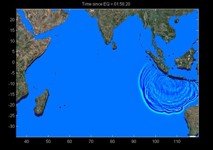
These images show results of the wave propagation throughout the Indian Ocean as well as its interaction with large underwater bathymetric features. The simulation was based on very preliminary and limited seismic information.


