TsuCAT - the Tsunami Coastal Assessment Tool
About
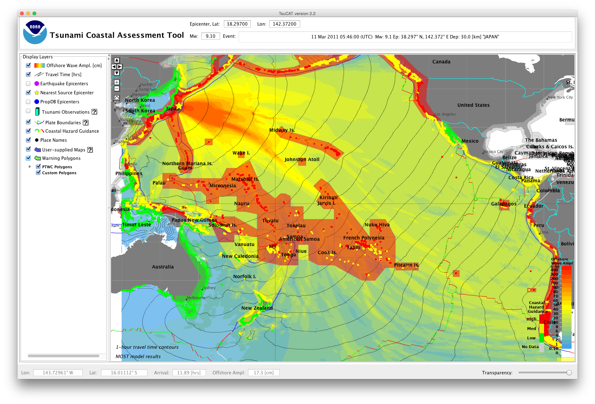
TsuCAT is a platform-independent application that was developed for hardware running Windows, Macintosh, and Linux operating systems and depends only on a Java installation (version 1.8 or higher). A graphical user interface gives access to NOAA’s Database of pre-computed tsunami arrival times and maximum amplitudes. In this software release, the Database is populated with results of modeling with the MOST model for magnitudes greater than Mw > 8.0 and with the RIFT model (used by PTWC) for magnitudes less than Mw < 8.0.
TsuCAT allows the user to view the effect of an earthquake at any location along a coastline using the Propagation Database by calculating the maximum wave amplitude for various combinations of unit sources using the relationships between rupture length and magnitude as outlined in Wells and Coppersmith (1994). Over 5,400 combinations are pre-calculated for magnitudes from Mw=6.5 to 9.6 in increments of 0.3, for all three major ocean basins: Pacific, Atlantic (including the Caribbean), and Indian. Presently, the scenarios do not cover the South China Sea and marginal seas of the Western Pacific.
In 2014, the U.S. Pacific Tsunami Warning Center (PTWC) ceased provision of watches and warnings for countries throughout the Pacific Ocean. Enhanced products that include wave amplitude were developed and are now provided to offer forecast guidance. The 2014 change now requires countries to be responsible for assessing their own threat, and deciding when to issue warnings based on their own alert level criteria. In an effort to assist countries in their decision making, the International Tsunami Information Center (ITIC) and NOAA Center for Tsunami Research (NCTR) developed the Tsunami Coastal Assessment Tool (TsuCAT) that was distributed to delegates to the Twenty-seventh Session of the Intergovernmental Coordination Group for the Pacific Tsunami Warning and Mitigation System (ICG/PTWS-XXVII, March 28-31, 2017)
TsuCAT provides access to a global database of tsunami modeling results from NOAA’s pre-computed catalog of sources (Propagation Database, GICA et al., 2008), and from NOAA’s RIFT model, to assist a country in its tsunami hazard assessment, tsunami exercise and response planning, warning decision-making, and education and outreach. Simulations for historical tsunami sources from NOAA’s National Centers for Environmental Information (NCEI) and the U.S. Geological Survey earthquake archive are also included. The tool is a ‘standalone’ application not requiring the Internet, and can be used for outreach in remote locations, as well as during events when telecommunications are down.
If you want more information on TsuCAT, please visit our collaborator, the International Tsunami Information Center
or contact us at christopher.moore@noaa.gov