| Learning from the Aitape Tsunami Hugh L Davies, Jocelyn M Davies, Wilfred Y Lus, Russell C B Perembo, Nelson Joku, Harrison Gedikile and Michael Nongkas Geology Department, University of Papua New Guinea, University PO, NCD hdavies@upng.ac.pg, wlus@upng.ac.pg, Russ.Perembo@upng.ac.pg | ||
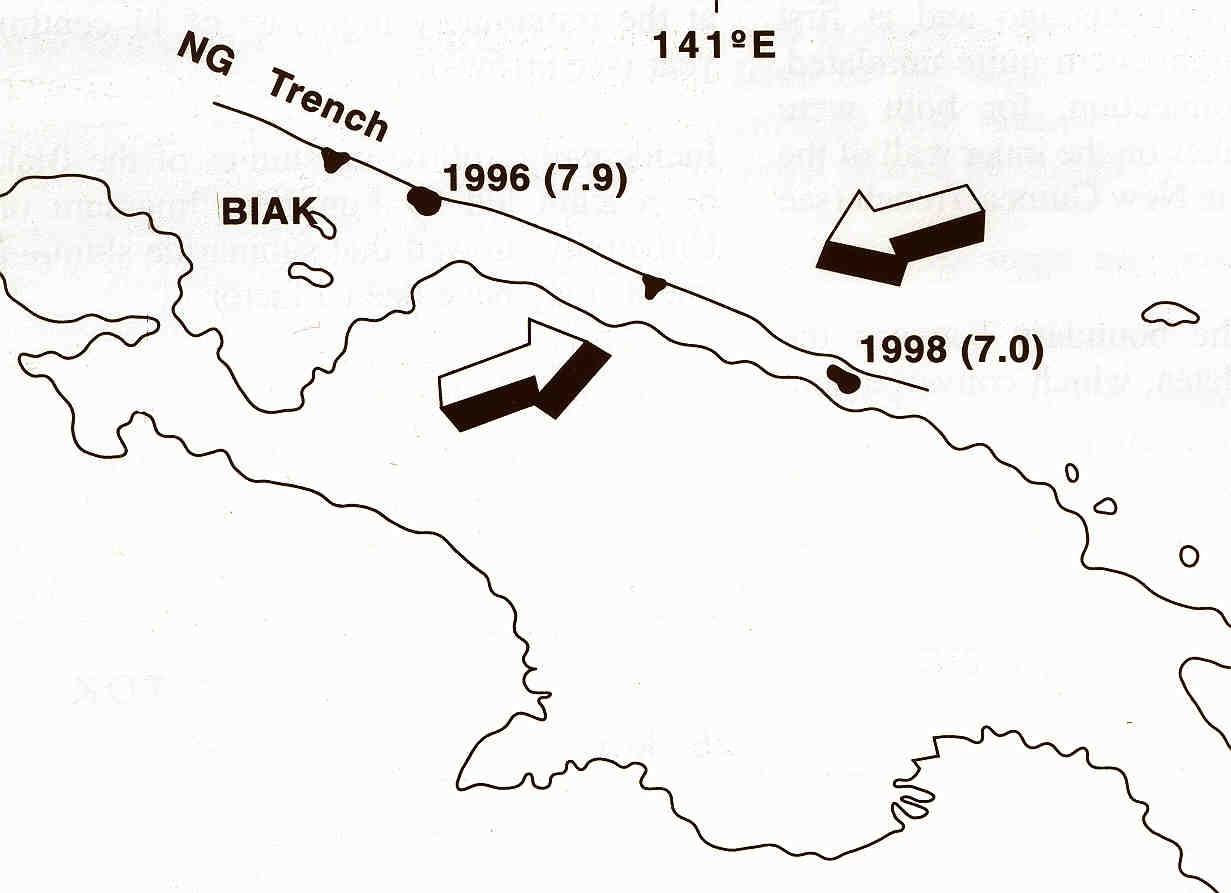 Earthquakes generated by rapid oblique convergence on the line of the New Guinea Trench caused tsunamis at Biak Island in 1996, 107 deaths, and at Aitape in 1998, more than 2200 deaths.
 Map of the Aitape coast. Bathymetric contours are from multibeam survey (Matsumoto et al., 1999). Sunken reefs have been identified at approximately 500 m depth and at 82 m depth. (The shallower reef is not shown; it is 8 km from shore.) Sissano Lagoon is the body of water inland from Warapu and Arop. The Sissano Government Station was at D and Nimas village (the easternmost Sissano village) at C. Sissano Mission was at B. Teles and Lambu villages of the Malol community, which were extensively damaged, extend from the mouth of the Yalingi River eastward to the mid point between Malol and Yakoi. The main focus of the wave was on the 14-km sector of coast from Mak to just beyond Warapu, D-E. Here the wave heights were 10 m or more, and destruction extended as far as 500 m inland. From the mouth of the Bliri River to Sissano (A-B), and from Mak to Tarau Point (F-H), wave heights were lower, mostly 4 m above sea level, and only structures near the water's edge were destroyed.
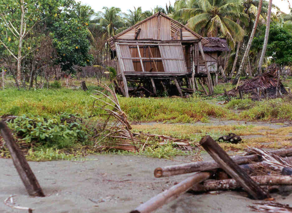 Although the waves were much lower east of the Yalingi River, Lambu and Teles villages were almost completely destroyed. Here the houses were on low sand ridges less than a metre above high water mark and within 100 m of the water's edge.
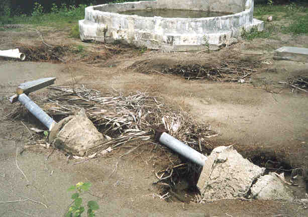 All that remained of Sissano Government Station office building were the foundations and part of a concrete water tank.
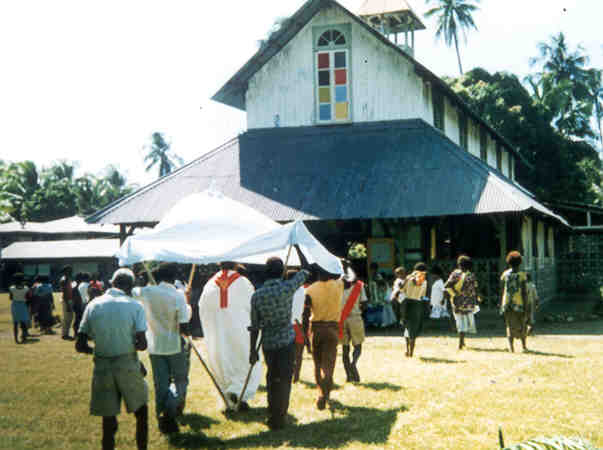 The church at Sissano built by German Divine Word missionaries in 1926, photographed in 1963.
 The site of the church after the tsunami. School buildings 400 m from the water's edge remained standing, though damaged. |
Abstract The Aitape, Papua New Guinea, tsunami of 17 July 1998 was focussed on a 14-km sector of coastline centred on the villages of Arop, Warapu and Nimas. Here the wave height was 10 m or more and all structures within 400-500 m of the shoreline were destroyed. More than 2200 people were killed and 10,000 survivors were forced to relocate inland. PNG-based researchers collected eye-witness accounts; mapped the pattern of destruction and the distribution and character of tsunami sediments; participated in marine investigations; and mapped and sampled underwater rock exposures that reveal a history of periodic, co-seismic(?) subsidence. They also provided information to the survivors and later convened a conference of scientists, survivors and managers from which a comprehensive account of the disaster, the response, and the recovery has been developed. Currently, for near-source tsunamis in PNG the only effective safety measure is to ensure that all people are aware of the warning signs of a tsunami and so know what to do, and that coastal settlements are planned with tsunamis in mind. The authors are participating in a nation-wide campaign to promote tsunami awareness and preparedness. 1. Introduction On the evening of Friday 17 July 1998, about 20 minutes after a strongly felt local earthquake, a succession of three large waves struck the Aitape coast of Papua New Guinea (Fig. 1). Waves 10-15 m high destroyed three villages, almost without trace. Confirmed deaths numbered 2200, a further 1000 suffered serious injury, and 10,000 were displaced from their homes. From the outset, experts were puzzled that such large waves could be generated by a moderate (M7) earthquake, and that the wave was so focussed, with most energy directed at a narrow sector of coastline. Subsequent investigations by international and locally-based scientists included two onshore investigations by international teams (the First and Second International Tsunami Survey Teams; Kawata et al., 1999), four major marine surveys by research ships from the Japan Marine Science and Technology Centre (JAMSTEC; Matsumoto, Tappin et al., this conference); one marine survey by a United States team (Sweet and Silver, 1999); and other onshore investigations by teams from Australia, New Zealand and the United Kingdom. Investigations by PNG-based scientists included interviews with survivors, mapping the damage, mapping and characterising the tsunami sediments, and first enquiries into the tsunami history and subsidence history of this coast. Other activities included a program of public awareness, firstly amongst the survivors, and latterly nationwide, and the organising of an international conference at which the disaster, the response and the recovery phase were reviewed by scientists, disaster managers, non-government organisation representatives and survivors. Other research has focussed on the mathematical modelling of the wave and re-interpretation of the earthquake data, aimed at determining the location and nature of the source. Results include the identification of a seismic signal that could have been generated by a submarine slump or landslide at Aitape 13 minutes after the initial earthquake (Synolakis et al., 2001). The outcome of the investigations is that most scientists believe that the tsunami was caused by a submarine slump or landslide, that presumably was triggered by the shaking of the initial earthquake. The finding has alerted communities around the world to the possibility that catastrophic tsunamis can arise from submarine gravity-driven mass movement, and do not necessarily require fault rupture. 2. The tsunami On the evening of Friday 17 July 1998, at 6.49 pm, 12 minutes after sunset, there was a strong earthquake, sufficient to cause some damage at the old church at Sissano and some liquefaction of sediments. There followed a loud boom, as though of thunder, and some minutes later a roaring sound, variously described as the noise of a low-flying heavy jet plane or as the woop-woop-woop of a heavy helicopter. People who had gone to the water's edge to look for the source of the noise saw the sea recede to below normal low-water mark, and then saw a wave develop. Most turned and ran for safety but almost all were caught by the wave which broke some hundreds of metres from the beach, approached rapidly, rose to tree-top height as it crossed the berm, then crashed down on their villages. 35 minutes after the initial earthquake, at around 7.25 pm, the destruction had ceased and calm had returned. It was now pitch dark. There was no moon and, in the Sissano area, the stars were blotted out by a low haze. Rescue began that night, the survivors helping each other. The first outside help arrived 16 hours after the event on the Saturday morning, and the major rescue effort began a day later, 40 hours after the event. By Monday evening (72 hours) all surviving injured were in hospitals at Vanimo, Raihu (Aitape) and Wewak (Davies, 2001). 3. Public awareness and information Based on experiences at the time of the volcanic eruption and mass evacuation of Rabaul in 1994, the PNG-based scientists were aware that there would be a need to provide information about the tsunami to the victims, to explain to them what had happened, to reassure them that it was a natural phenomenon, and to be available to answer their questions. As part of their briefing for Government officers in Port Moresby in early August, the members of the First International Tsunami Survey Team (Kawata et al., 1999) confirmed the urgent need to get reliable information to the disaster managers in the field, and to the survivors. A public information and awareness program was begun in early August 1998 and has continued to the present. 4. Survivor interviews In the process of giving information to the survivors much was learned about the tsunami. In particular, survivor stories about the timing of the arrival of the wave (Davies, 1998a: 26-30) were a factor in persuading most investigators that the wave was caused by movement of sediments after the earthquake, rather than by co-seismic rupture on a fault (Davies, 1998a: 7-8; Tappin et al., 1999). Fishermen had witnessed the escape of gas from the sea floor before the earthquake, and survivors told of a kerosene or oily smell in the wave (Davies, 1998a: 16). Their stories reinforce the possibility that a sudden release of natural gas was in some way linked to the development of the tsunami. The escape of a large volume of gas could explain the otherwise puzzling observation by most survivors that the water in the wave was unusually warm. Escape of gas in the eastern Mediterranean is known to have raised the temperature of sea water by as much as 6oC (Soter, 1999) Eyewitnesses also provided useful information about the shape of the wave, how it had come ashore first at a point on the coast at or near Mak (E in Fig. 1), and had progressed westward along the coast. The westward progression of the wave, and hence its obliquity to the coast, was confirmed by mapping of the damage which, in this sector, shows trails that extend at an angle southwestward away from the coast, rather than normal to the coast. 5. Mapping the tsunami sediments Following on from the initial reconnaissance studies by Jaffe et al. (this conference), several transects were surveyed and tsunami sands sampled and studied. Generally the sands are around 10 cm thick, but are much thinner in the coastal strip, within 100 m of the shore, and much thicker at locations where the wave travelled down slope, such as at the seaward edge of Warapu and Arop villages, and at the seaward edge of the road near the coast east of Malol (Fig. 1), where deep scour-holes were filled with sand. Near the rocky headland at Tarau Point, east of Aitape, the waves scoured a pot hole and filled it with sand to a depth of at least 1.7 m (Davies, 1998a: 22-23). Size fractions were determined for all samples but results are not yet published. 6. Subsidence Evidence that the lagoon area has a long history of subsidence was discovered in September 1999, when we investigated reports that cracks were developing in the lagoon floor. Just inside the lagoon mouth, a steep face that had been exposed by the erosive action of tidal currents revealed a 2-m section through the sediments that underlie the lagoon. The sediments between 2 and 3 m below sea surface comprised a homogeneous sticky mud, weakly bedded, that showed the traces of former plant roots. This is lagoonal mud, perhaps deposited since the 1907 subsidence event. The sediments at 3 to 4 m below sea surface were a spectacular alternating sequence of pale grey, sticky muds and black peat beds. Some of the peat beds were only a few cm apart and others were as much as 15-20 cm apart. We took this to be evidence of repeated subsidence, presumably co-seismic. Material from the lowermost exposed peat bed was dated by carbon-14 method at 990 years plus or minus 70 years BP (present is standardised at the year 1950; A. Hogg, Report on sample Wk-7864, 8 November 1999, Radiocarbon Dating Laboratory, University of Waikato). The result indicates a total subsidence of at least 4 m in the last 970-1100 years. 7. Frequency of tsunamis Based on written records of mission workers, there has been no catastrophic tsunami on the Aitape coast for at least 102 years. This is contrary to some reports, including that of Carey (1935), who wrote of a tsunami at the time of the 1907 earthquake and subsidence event. However, there certainly have been damaging tsunamis in pre-historic time. At least one of the village groups has an oral history story of a major tsunami that approached from the west (Davies, 1998a: 37-38 and unpublished interviews), and during the peat-sampling dive in 1999 we noted at least one of the submerged peat beds contained a significant concentration of sand, probably indicating a major tsunami. The sedimentary record will be investigated more thoroughly by drilling in August 2001. 8. Advice to government Another role for the PNG-based scientists has been to advise the government and the survivors about the safety of this sector of coastline. Factors against returning to this part of the coast are: * The modellers have demonstrated conclusively that the maximum energy of any tsunami generated in this region will be focussed on the same sector of coast. This is because of the focussing effect of the broad shelf and the adjacent submarine canyon and embayment. * Villages on the frontal sand barrier, from Mak to Sissano, have poor escape routes. * There is at present no cost-effective warning system for tsunamis that originate within 40 km of the coast, on the inner wall of the New Guinea Trench, which is the most likely source region. References Carey, S.W. (1935): Preliminary notes on a recent earthquake in New Guinea. Australian Geographer 2(8), 8-15. Davies, H.L. (1998a): Tsunami PNG 1998 - Extracts from Earth Talk. Waigani: University of Papua New Guinea. Davies, H.L. (2001, in prep.): Report on the Aitape 1998 Tsunami. Waigani, PNG National Disaster Management Office. Kawata, Y., Benson, B.C., Borrero, J.C., Borrero, J.L., Davies, H.L., deLange, W.P., Imamura, F., Letz, H., Nott, J., and Synolakis, C.E. (1999): Tsunami in Papua New Guinea was as intense as first thought. EOS Transactions of the American Geophysical Union 80, pp. 101, 104-105. Synolakis, C., Bardet, J-P., Borrero, J., Davies, H., Grilli, S., Okal, E.,Silver, E., Sweet, S., Tappin, D., and Watts, P. (2001): The slump origin of the 1998 Papua New Guinea tsunami. Proceedings of the Royal Society (in press). Soter, S. (1999): Macroscopic seismic anomalies and submarine pockmarks in the Corinth-Patras rift, Greece. Tectonophysics 308:275-290 Sweet, S., and Silver, E.A. (2001): Seismic reflection images of the source region of the 1998 Papua New Guinea tsunami. In: Watts, P., Synolakis, C.E., and Bardet, J.P., (eds) Prediction of Underwater Slump and Slide Hazards. Rotterdam, Balkema. Tappin, D.R., Matsumoto, T., Watts, P., Satake, K., McMurtry, G.M., Matsuyama, M., Lafoy, Y., Tsuji, Y., Kanamatsu, T., Lus, W., Iwabachi, Y., Yeh, H., Matsumoto, Y., Nakamura, M., Moihoi, M., Hill, P., Crook, K., Anton, L., and Walsh, J.P. (1999): Sediment slump likely caused the 1998 Papua New Guinea tsunami. EOS Transactions of the American Geophysical Union 80, pp. 329, 334, 340. |
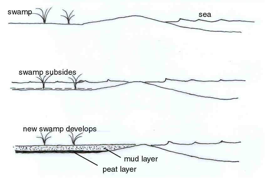 Diagram, from a pamphlet distributed to local villagers, shows how the peat layers may have formed.
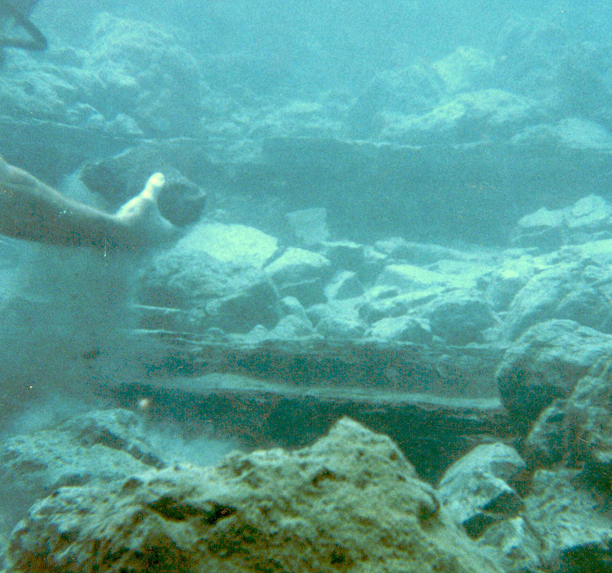 Sediments exposed by tidal erosion at the lagoon mouth are alternating lagoonal muds (pale colour) and peat (dark). Peat collected from 4 m below surface was dated at about 1000 years before present. At least one of the peat beds is very sandy and may record a major pre-historic tsunami. The section will be sampled by drilling in August 2001.
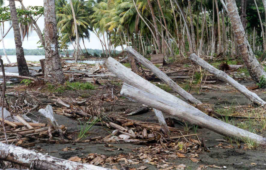
 At Tarau Point, at the eastern end of the tsunami damage area, the waves scoured a hole about 10 metres across and 2 metres deep, and filled it with sand and rip-up clasts.
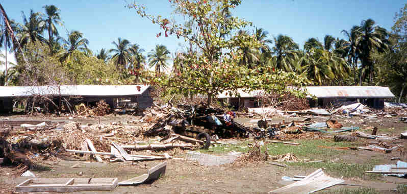
 Photograph of part of Warapu village taken in 1992
 Part of Warapu village after the tsunami
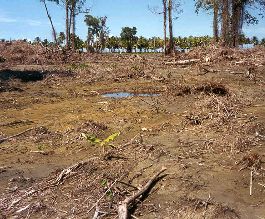 At Arop School the waves penetrated 500 m inland, carrying away and stacking tall trees. The photograph taken two months after the tsunami shows how all vegetation was swept away. The water-filled craters mark where trees were uprooted. The line of coconut palms along the foreshore was not damaged. |