|
|
  |
F.I. Gonzalez, E.N. Bernard, H.B. Milburn, S. Stalin, V.V. Titov, H.O. Mofjeld,
M.C. Eble, J.C. Newman, R.A. Kamphaus, E.F. Burger
NOAA / Pacific Marine Environmental Laboratory |
  |
|
A deep ocean network, combined with a numerical model database, will improve the speed and accuracy of short-term tsunami forecasting
|
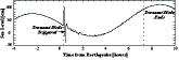
Earthquake!Tsunami? |
| Time = 0 |
|
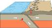 |
Destructive tsunamis originate primarily in subduction zones around the Pacific Rim. |
Not every earthquake generates a tsunami. |
| Model simulations combined with real-time tsunami measurements will help assess the hazard. |
|
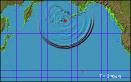 |
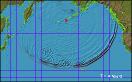
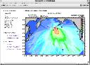
| A simulated tsunami generated by a large subduction earthquake (Mw = 8.5) in Alaska-Aleutian Subduction Zone. |
 |
|
|
 |
Data Network |
 |
|
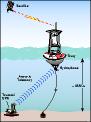 |
Deep-ocean
Assesment and
Reporting of
Tsunamis
System |
|
|
 |
Quality Control Web Page
 |
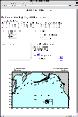
Surface Buoy and BPR Deployment |
 |
Simulated Tsunami and DART Reporting Modes |
 |
| |
|
Model & Data Assimilation |
 |
|
 |
Tsunami
Propagation
Database
Interface |
Output: Time Series
 |
Output: Maximum Wave Heights
 |
 |
Site-Specific
Tsunami
Inundation
Modeling |
| |
|
Tsunami Forecast Guidance |
| Time = 1 hour |
Hawaii Civil Defense must decide whether to call a tsunami evacuation within an hour of a Pacific earthquake.
The integrated DART/model database system will provide more rapid and accurate guidance to emergency managers.
Schedule:
An operational network of six DART stations will be deployed over the next two years.
The data-assimilation scheme and database for Hawaii are presently under development, to be completed by 2003.
|
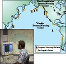 |
| Tsunami Warning Center |
 |
| |
Support provided by NOAA, the U.S. National Tsunami Hazard Mitigation Program and NASA/DoD Solid Earth and Natural Hazards Program
Home | Tsunami Forecasting | Research | DART | Events | Info

| | |
| | |