Preface
A project is underway to assess the tsunami hazards within Puget Sound communities and to provide information for tsunami planning and mitigation. It is one of the Tsunami Inundation Modeling Efforts within the National Tsunami Hazard Mitigation Program. It is recognized that the Seattle Fault zone. Using a finite difference model based on nonlinear shallow water wave theory and high-resolution digital elevation model, we simulate the generation, propagation, and inundation of tsunamis in Puget Sound. The tsunamis are generated as a result of possible earthquake scenarios for the Seattle Fault. The initial focus is on the major population centers and ports within the Main Basin, its bays, and side-inlets.
Background
It is recognized in western Washington state that significant seismic hazards are induced on the major populated regions in the Puget Lowland. An earthquake of Mw = 6.8 occurred at Nisqually, Olympia on February 28, 2001 and six earthquakes of M > 6 have occurred in western Washington State. These events were intraslab earthquakes, so called Benioff Zone earthquakes except for the 1872 event at the eastern side of Cascadia range. However, little seismicity in the shallower crust do not demonstrate that no concern is required for seismic hazards by shallow crustal earthquakes and also for generation of tsunamis.
Paleoseismic studies in the Puget Lowland of western Washington demonstrate that an earthquake of M > 7 occurred on the shallow crustal fault, which is called the Seattle Fault, 1100 years ago (Bucknam et al., 1992). It is believed that tsunami was accompanied by this earthquake. Atwater and Moore (1992) found the tsunami deposits at West Point and Cultus Bay which locate north of the Seattle Fault. Also, recent geophysical investigations suggest that the Seattle Fault is active and capable of generating a large earthquake of M > 7 (Pratt et al., 1997, Johnson et al., 1999, Brocher et al., 2000).
This project aims to simulate and map the tsunami hazards within Puget Sound communities which might be induced by the potential shallow crustal earthquakes, using a conventional finite difference model based on the nonlinear shallow water theory and high-resolution bathymetry/topography data of Puget Sound.
Contents
List of Figures
- Figure 1 : Inferred structure of the Seattle Fault.
- Figure 2 : Computed seismic deformation due to the hypothetical earthquake on the Seattle Fault.
- Figure 3 : Computed tsunami waveforms at major ports and harbors in Puget Sound, due to the Seattle Fault earthquake.
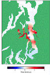
- Figure 4 : Tsunami inundation map of the Seattle waterfront area.
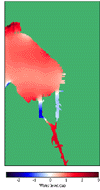
- Figure 5 : Tsunami inundation map of Bremerton and Port Orchard area.
Seattle Fault
According to the recent seismological studies, the Seattle Fault is believed to be a zone of thrust or reverse faults that strikes through Seattle in the densely populated Puget Lowland of western Washington (Johnson et al., 1999). The structure of the Seattle Fault zone still have great uncertainty and there exist a number of interpretations.
Based on the seismic reflection data, Pratt et al. (1997) proposed the thrust sheet hypothesis on the Seattle Fault structure, which interprets that the deeper portions (> 5 km) of the fault is dipping southward at an angle of 20 degree and shallower portions (< 5 km) is dipping at an about 45 degree. They estimated the possible magnitude on the Seattle Fault to be Mw=7.6 to 7.7.
Based on the distribution of bedrock, anomalies in the earth's magnetic and gravity fields, and seismic-reflection data, Johnson et al. (1999) inferred that the Seattle Fault forms west-trending zone of three or more south dipping reverse faults. They also interpreted that the Seattle Fault forms a 4 to 6 km wide, west-trending zone and mapped the zone in waterways across the Puget Lowland for at least 40 km from Dyes Inlet to Lake Washington. They concluded that the fault was not recognized in Hood Canal.
A group of geophysicists working on a project (Brocher et al., 2000), called Seismic Hazard Investigations of Puget Sound (SHIPS), conducted their investigations of the upper crustal structure of the Puget Lowland, using marine airgun sources and recorders in 1998 (Wet SHIPS), obtaining the seismic refraction line of the studied area in 1999 (Dry SHIPS) and recording the demolition of the Seattle Kingdome sports stadium with an array of seismic recorders in 2000 (Kingdome SHIPS). They inferred that the length of the Seattle Fault is at least 70 km and the fault could produce a M=7.2 to 7.5 earthquake for a fault length of 70 km and fault plane depths between 20 to 30 km. The dip angle of the fault plane has not yet been well resolved by SHIPS.
Considering the above interpretations, we assume a M7.2 earthquake on the Seattle Fault which covers an area of 60 km by 19 km as a possible tsunamigenic earthquake. We adopt the interpretation of Johnson et al. (1999) for the horizontal structure of the Seattle Fault. Also we adopt and slightly modify the thrust sheet hypothesis proposed by Pratt et al. (1997) for the vertical structure of the fault, to determine dip angles as 25 degree for the deeper fault plane (> 5.5 km) and 60 degree for shallower fault plane (< 5.5 km). Fig. 1 indicates the inferred horizontal structure of the Seattle Fault. We divide the fault plane into 12 segments to fit the inferred structure by Johnson et al. (1999). Strike angle of each segment is determined by the inferred structure shown in Fig. 1.
For the determination of the amount of fault displacement, we apply the empirical relationship between fault displacement and earthquake magnitude proposed by Wells and Coppersmith (1994). Table 1 indicates the determined fault parameters for estimating the seismic deformation by the fault movement. n is the number of segments of upper and lower fault plane, L and W are strike length and downdip width of each segment and H is the depth of top edge of each segment. Based on the parameters shown in Table 1 , we estimate the vertical seismic deformation of the land and sea bottom by using the theory of Okada (1985) to compute the static displacement due to inclined and tensile fault in a half space.
Fig. 2 shows the computed vertical seismic deformation of the land and sea bottom within Puget Lowland. The result shows 2.3 m of maximum uplift at the sea bottom between Bainbridge Island and Elliott Bay, Seattle.
Go to top
Numerical model
We apply the TUNAMI-N2 model (Imamura, 1995) for modeling propagation and coastal inundation of tsunamis in Puget Sound. In this model, a set of nonlinear shallow water equations with bottom friction term are discretized by the leap-frog finite difference scheme. This model is widely used to simulate tsunami propagation and inundation on a dry land.
For the modeling of tsunamis, we use the digital elevation data provided by PRISM (Puget Sound Regional Synthesis Model). This data is compiled from USGS digital elevation models and NOS GODAS Bathymetry. The original grid size is 30 m and the datum for the elevation is based on NAVD29. We focus on an area of (47.2N,123.0W)-(48.0N,122.1W) as a computational domain. For the computation of tsunamis within broad area of Puget Sound, we resampled the original data to create 90 m grid. For the inundation modeling within populated region such as Seattle or Bremerton, we use the original 30 m grid, constructing a nested grid system with 90 m grid.
Table 2 : Computational conditions Governing equation Non-linear shallow water wave equation Numerical scheme Leap-frog FDM Spatial grid size 90m/30m* Temporal grid size 0.5 sec. Computational domain (47.2N,123.0W)-(48.0N,122.1W)
Go to top*Bathymetry and topography data was provided by PRISM (Puget Sound Regional Synthesis Model).
Modeling results
Fig. 3 shows the computed tsunami waveforms at major ports and harbors in Puget Sound ; Mukilteo (MK), Kingston (KN), Edmonds (ED), Northern shore of Elliott Bay (NHB), Head of Elliott Bay (HEB), Bremerton (BR), Port Orchard (PO), Vashon (VS) and Tacoma (TC). Location of each port is shown in Fig. 1. The computation is performed under the assumption of mean tide during the event. The tsunami strikes Elliott Bay with more than 3 m of its water level at the northern shore and 1.5 m at the head of the bay right after the earthquake. This result suggests that we should expect inundation at the Seattle waterfront area. At Bremerton and Port Orchard, local seismic uplift generates 1.5 m tsunami at the moment of the earthquake, then the water is receded. At Tacoma, positive tsunami waves arrive within approximately 10 minutes and 1.5 m tsunami appears at 20 minutes. Tsunamis less than 1 m strike the ports and harbors other than those mentioned above. However, note that the tidal range within Puget Sound is approximately 3 m. If the tsunami strikes during high tide, we should expect more serious hazards which impacts local coastal communities.
Fig. 4 and Fig. 5 show the tsunami inundation maps of the Seattle waterfront area, and Bremerton and Port Orchard area, which are both developing populated waterfront communities. The figures describe the distribution of maximum inundation depths on the land, which is measured from the local ground to the surface of surging water. For these areas, we carried out the detailed modeling of tsunami inundation based on the nested 30 m grids. The inundation map of the Seattle waterfront area shows that the heavy inundation occurs at Pier 90, 91 with the flow depth of more than 2 m, and at Pier 55 to 77 and Pier 36 to 54 with approximately 1 m flow depth. Inundation map at Bremerton and Port Orchard area shows that the inundations mainly occur along the southern shore of Sinclair Inlet and the northern and southern shore of Dyes Inlet. The estimated flow depths are up to 2 m at the shore 1 km east of Port Orchard, 4 m at the northern shore of Dyes Inlet and 2 m at the southern shore of the inlet because of local seismic uplift and trapped tsunamis within the inlet.
Go to top
Tsunami model movies

Central Puget Sound Seattle Waterfront Bremerton and Port Orchard
Go to top
References
Go to top
- Atwater, B. F. and A. L. Moore, A Tsunami about 1000 Years Ago in Puget Sound, Washington, Science, v.258, pp.1614-1617, 1992
- Brocher, T. M., T. L. Pratt, K. C. Creager, R. S. Crosson, W. P. Steele, C. S. Weaver, A. D. Frankel, A. M. Tr\'{e}hu, C. M. Snelson, K. C. Miller, S. H. Harder and U. S. ten Brink, Urban Seismic Experiments Investigate Seattle Fault and Basin, EOS, Trans. AGU, v.81, pp.545, 551-552, 2000
- Bucknam, R. C., E. Hemphill-Haley and E. B. Leopold, Abrupt Uplift within the Past 1700 Years at Southern Puget Sound, Washington, Science, v.258, pp.1611-1614 , 1992
- Imamura, F., Review of Tsunami Simulation with a Finite Difference Method, Long-Wave Runup Models, World Scientific, pp.25-42, 1995
- Johnson, S. Y., C. J. Potter and J. M. Armentrout, Origin and Evolution of the Seattle Fault and Seattle Basin, Washington, Geology, v.22, pp.71-74 , 1994
- Johnson, S. Y., S. V. Dadisman, J. R. Childs and W. D. Stanley, Active Tectonics of the Seattle Fault and Central Puget Sound, Washington - Implications for Earthquake Hazards, GSA Bulletin, v.111, no.7, pp.1042-1053, 1999
- Johnson, S. Y., C. J. Potter, J. M. Armentrout, J. J. Miller, C. Finn and C. S. Weaver, The Southern Whidbey Island Fault : An Active Structure in the Puget Lowland, Washington, GSA Bulletin, v.108, no.3, pp.334-354, 1996
- Okada, Y., Surface Deformation due to Shear and Tensile Faults in a Half-space, Bulletin of the Seismological Society of America, Vol. 75, No.4, pp1135-1154 , 1985
- Pratt, T. L., S. Johnson, C. Potter, W. Stephenson and C. Finn, Seismic Reflection Images beneath Puget Sound, Western Washington State : The Puget Lowland Thrust Sheet Hypothesis, Journal of Geophysical Research, Vol.102, pp.27469-27489 , 1997
- Wells, D. L. and K. J. Coppersmith, New Empirical Relationships among Magnitude, Rupture Length, Rupture Width, Rupture Area, and Surface Displacement, Bulletin of the Seismological Society of America, Vol. 84, No.4, pp.974-1002 , 1994
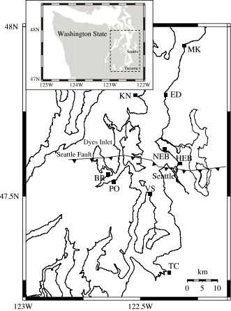
Figure 1 : Inferred structure of the Seattle Fault. Abbreviations as follows : MK=Mukilteo, ED=Edmonds, KN=Kingston, NEB=Northern Elliott Bay, HEB=Head of Elliott Bay, BR=Bremerton, PO=Port Orchard, VS=Vashon, TC=Tacoma.
Table 1 : Dimension and source parameters of the Seattle Fault.
Shallower Fault Deeper Fault n 6 6 L (Total strike length) 60.0 km 60.0 km W (Downdip width) 6.0 km 13.0 km D (Dislocation) 2.8 m 2.8 m D (Depth of the top edge of the fault) 0.5 km 5.5 km Dip angle 60 degree 25 degree Slip angle 90 degree 90 degree
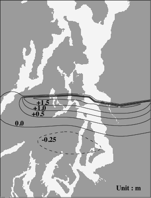
Figure 2 : Computed seismic deformation due to the hypothetical earthquake on the Seattle Fault.
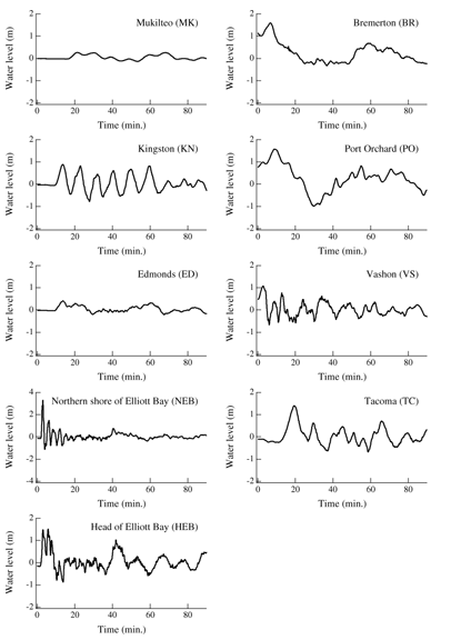
Figure 3 : Computed tsunami waveforms at major ports and harbors in Puget Sound, due to the Seattle Fault earthquake.
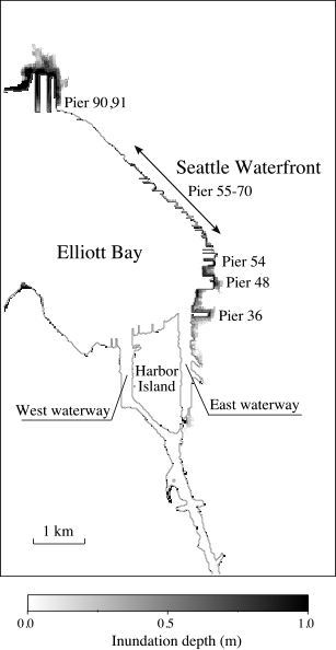
Figure 4 : Tsunami inundation map of the Seattle waterfront area.
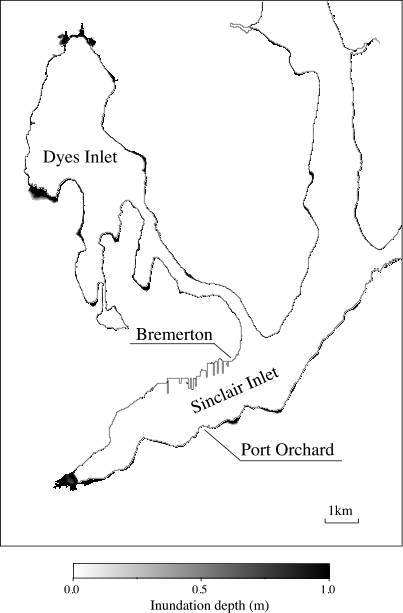
Figure 5 : Tsunami inundation map of Bremerton and Port Orchard area.
U.S. Department of Commerce
NOAA | OAR
Pacific Marine Environmental Laboratory
Tsunami Research ProgramUpdated: July 15, 2005
Disclaimer of External Links
Credit NOAA & Terms of Use
Privacy Policy