Puget Sound Tsunami Sources Workshop
Organized by NOAA/TIME, USGS and WA EMD
1. Background
NOAA, the USGS and the State of Washington are partners of the U.S. National Tsunami Hazard Mitigation Program (see http://nthmp-history.pmel.noaa.gov/). A major goal of the NTHMP is to develop tsunami inundation maps for at-risk coastal communities, using best available science. These maps are used by Emergency Management officials at the State, County and Municipal level as essential guidance in the development of hazard mitigation products such as evacuation maps and outreach/educational programs. This effort provides the basis for community development of a mitigation plan that is in compliance with the Washington State Growth Management Act. Examples of both modeling and emergency management products are provided in Appendix A.
In 2003, the NOAA Center for Tsunami Inundation Mapping Efforts (http://www.pmel.noaa.gov/tsunami/time/) at the Pacific Marine Environmental Laboratory will begin running numerical model simulations to develop inundation maps for high-priority areas in Puget Sound. Source specification is critical to numerical simulation of tsunami generation and runup.
On 24 April 2002, a pre-workshop meeting of the Organizing Committee was held at the TIME Center to plan the workshop and prepare pre-workshop material.
2. Purpose
The purpose of the workshop is to develop quantitative descriptions of potential Puget Sound tsunami sources, suitable for use in numerical simulations of tsunami inundation.
3. Strategy
Our strategy will be to concentrate on four high-priority areas, provide resource and reference material and data for each, and focus on the development of "scenario matrices" that summarize parameter estimates for potential sources.
Statistical/probabilistic methods would be very useful in the production of inundation maps. To this end, we will ask participants to consider two categories of sources:
High Priority Areas
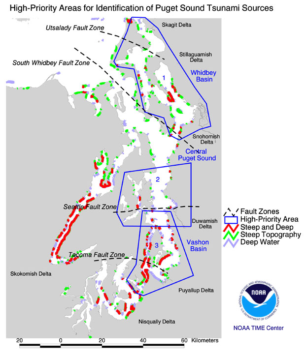
Four high-priority areas have been identified: the Whidbey Basin, Bainbridge Basin, Elliott Bay and Vashon Basin areas (Figure 1). As is evident from Figure 1, each area could be subjected to a tsunami generated by earthquake and/or landslide and/or river delta failure. The exception is the Bainbridge Basin area, which does not possess a large river delta.
Source Parameter Matrices
The Organizing Committee will develop and present strawman scenario matrices that summarize potential source parameter estimates. Participants are encouraged to contribute their own scenario matrices. The use of these matrices will focus the workshop on developing quantitative estimates of source parameters for earthquakes, landslides and delta failure scenarios. Matrix templates are presented in Appendix B.
Figure 1. Three Puget Sound high-priority areas, including four known or suspected fault zones, several large river deltas and the results of a simple GIS analysis that suggests landslide potential -- red coastal areas are those characterized by steep topography (exceeding 50 m height within 150 m of shore) and adjacent deep water (exceeding 30 m depth within 200 m of shore). (Note: The Central Puget Sound area was formed by combining the two areas previously identified as the Bainbridge Basin and Elliot Bay areas.)
4. Structure and Agenda
The general format of the workshop will be as follows (a more detailed agenda will be provided later):
Duration: 8:30 am to 4:30 pm, with Lunch Break
Appendix A
Examples of Modeling and Emergency Management Products
Examples of Inundation Modeling Products.
These are taken from the recent Seattle Tsunami Inundation Modeling Project conducted by the TIME Center for the State of Washington.

1. Earthquake Source Deformation. Only tsunami generation by vertical crustal displacement of an Mw=7.3 Settle Fault earthquake was modeled. No landslide or river delta slumping was considered.
2. Tsunami Simulation Snapshot. Taken a few minutes after generation by the earthquake, as modeled by the Method of Splitting Tsunami (MOST) model, developed by Vasily Titov. The initial tsunami waveform was assumed to be identical to the earthquake source deformation field, shown above.
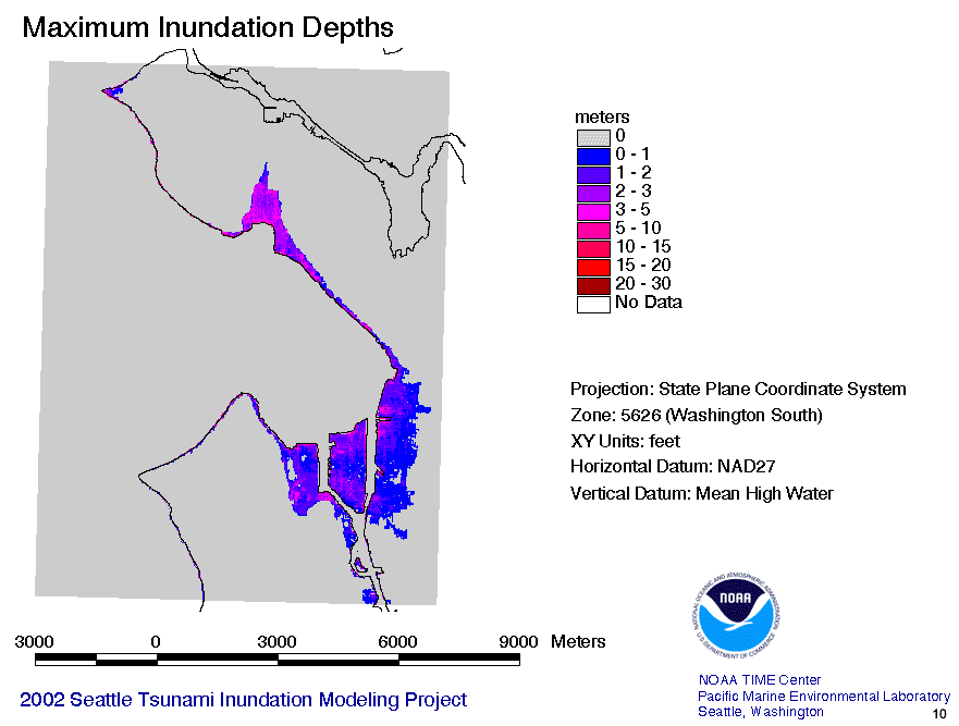
3. Derived Product. From the MOST model simulation can be derived the maximum inundation depth value achieved at each point on land during the course of the entire simulation.
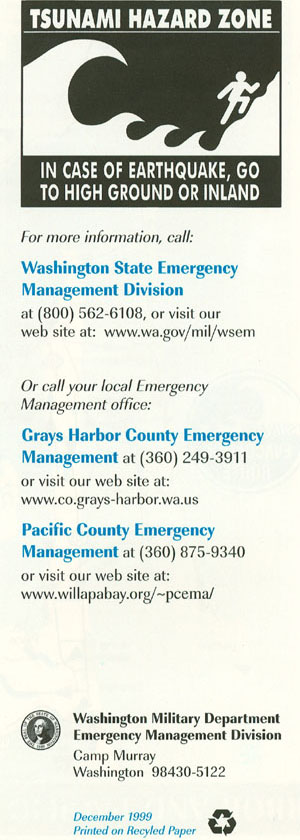
Examples of Emergency Management Products.
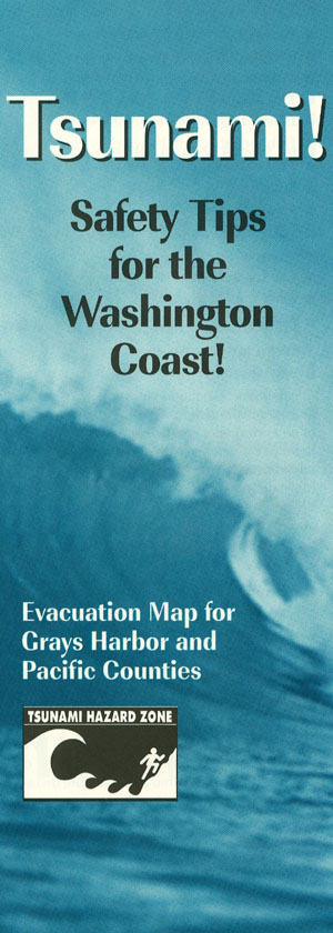
Seattle products are still under development. These are examples of emergency management products developed by the State of Washington with guidance from previous inundation modeling by the Oregon Graduate Institute of the Southwest coast of Washington, including Willapa Bay, Washington.
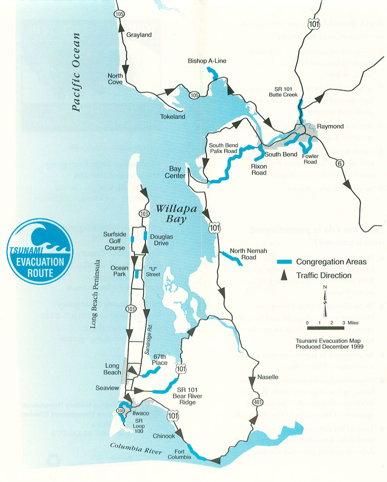
Evacuation Map and Brochure for Willapa Bay. The Willapa Bay area Evacuation Map presents recommended traffic routes and congregation areas. The map is part of a brochure that includes additional safety, educational and outreach information. The back of the brochure provides contact information.
Appendix B
Scenario Matrix Templates
Parameter Estimates Matrix
Potential Earthquake Scenario
Source Type (circle one): A. Site-specific Source B. Design Source
| Parameter |
Probable Range of Values (MKS Units) |
Confidence in Your Estimate (On a scale of 0-10) |
Probability of Occurrence (% prob. in N yrs) |
| Location | |||
| Magnitude | |||
| Fault Plane Geometry | Length: Width: Depth: Dip: Strike: Slip: |
||
| Surface Rupture ? | |||
| Shaking (g's) | |||
| Duration (seconds) | |||
| Other |
Parameter Estimates Matrix
Potential Landslide and/or Delta Failure Scenario
Source Type (circle one): A. Site-specific Source B. Design Source
| Parameter |
Probable Range of Values (MKS Units) |
Confidence in Your Estimate (On a scale of 0-10) |
Probability of Occurrence (% prob. in N yrs) |
| Location | |||
| Geometry |
Length: Width: Thickness: |
||
| Speed | |||
| Slope Angle | |||
| Aspect |