NOAA NCTR research product Not an official forecast |
Local Impacts
Solomon Islands Event Page | Local Impacts | Model and Data Comparison Plots
 |
|
| Maximum computed amplitude at Bairiki, Kiribati. The island of Bairiki (containing the capital, South Tarawa) has a mean elevation of just 1.49 meters. |
|
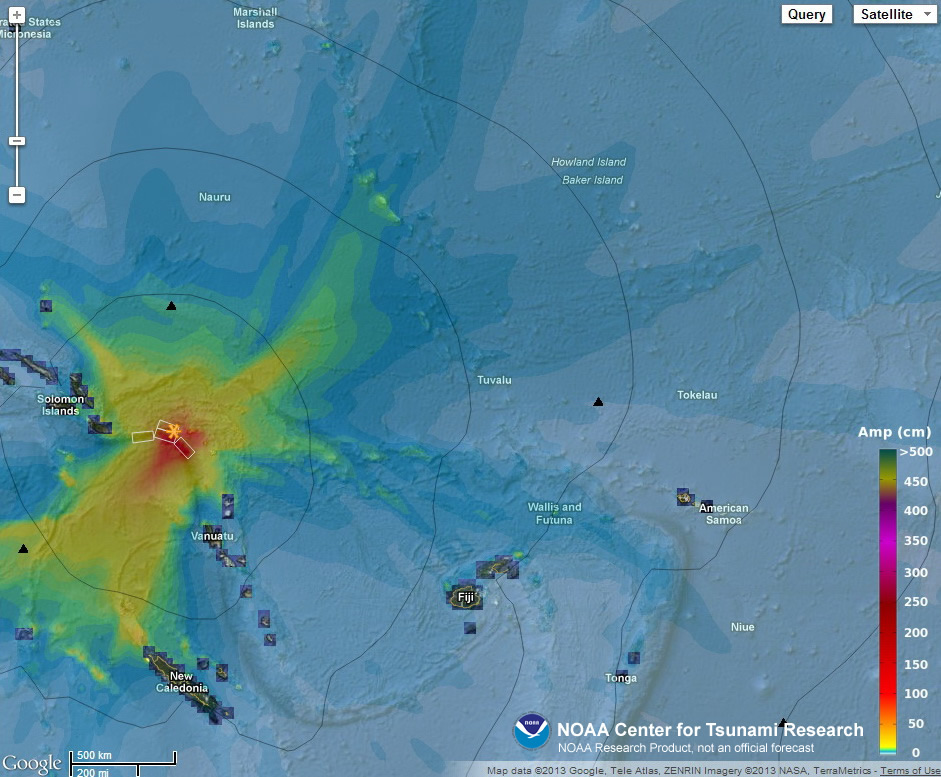
Many Pacific island territories and nations are at risk from tsunamis generated in this region and, indeed, the Solomon Islands were particularly hard hit during this event.
As an outreach project, NOAA has collaborated with its sister organization in Australia, the Australian Bureau of Meteorology (BOM), and the United Nations' Intergovernmental Oceanographic Commission to produce the Community Model Interface for Tsunami (ComMIT) and to conduct workshops on its use. ComMIT workshops draw on experts from NOAA and Australia to teach designated individuals from interested countries the numerical modeling techniques used in NOAA's tsunami forecast system. Exactly one year ago from the date of this tsunami event, a ComMIT workshop was taught with participants drawn largely from the region surrounding this earthquake epicenter.
During the tsunami event, a participant from Kiribati exercised ComMIT and shared with us a ComMIT model run for the island of Bairiki including the capital, South Tarawa, showing a maximum inundation of 41.5 cm based on the bathymetry available during the training session. Even with this relatively low-resolution bathymetry, ComMIT model results compare well with observations at the local tide gauge.
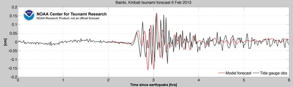 |
| Model comparison with tide gauge at Bairiki, Kiribati. |
A follow-up ComMIT workshop for this region is scheduled for April 2013, during which participants will have the opportunity to work with NOAA/BOM scientists to develop an improved bathymetry and topography grid and further their modeling skills. Representatives from both Kiribati and the Solomon Islands are planning to attend.
Disclaimer: The forecasts on these pages show the results of ongoing research to enhance tsunami science and to improve NOAA operational tsunami forecasts. These products were developed during or shortly after the tsunami event, are intended for research use, and are not an official forecast. They should not be used as the basis of any public or private policy decisions. Please contact NCTR to find if there are more detailed follow-on analysis results.