United Kingdom Hydrographic Office, FIRST IMAGES OF HMS SCOTT'S SURVEY ARRIVE AT UKHO
Bulletins from HMS Scott
Christian K Wilson, British Geological Survey
Febuary 15, 2005 Bulletin from HMS Scott
The survey is now complete and we are on passage to port. During the last 20 days we have acquired data over a distance of more than 8000 km, covering an estimated area of approximately 40 000 square kilometres over the southern part of the December 26, 2004 earthquake rupture zone.
During the survey, we have visited the main sections of the subduction zone forearc, including the plate boundary and accretionary wedge, the forearc high and forearc basin. We have also transited across parts of the Great Sumatran Fault.
In the context of the international response to the earthquake and tsunami, we have endeavoured to inform the scientific community of our progress by providing bulletins and selected images of representative features revealed for the first time. Many of you have read the exaggerated media interpretations of these images - rest assured these interpretations are not ours! There is no doubt that the feedback we have had from our numerous scientific colleagues reflects the impact and significance of the images we have provided. Onboard HMS Scott, we have spent many hours debating and discussing the significance of the data we have acquired. We look forward to presenting the results and our interpretations of the data in their full context.
We take this opportunity to thank all involved with the HMS Scott survey, both those onboard and those ashore.
The onboard scientists (Dave Tappin, Lisa McNeill, Tim Henstock)
Febuary 2005 Bulletin from HMS Scott
We have completed the survey of the accretionary wedge and are now carrying out a final scientific transit parallel to our lines running into the region. All the initial aims for the data acquisition phase of the project have been met. The portion of the deformation front within the Indonesian EEZ was surveyed from the Indian/Indonesian median line to a point offshore of Simeulue. The survey was continued to the upper parts of the accretionary wedge along the majority of the region, and the margins of the forearc (Aceh) basin were covered. In addition, several transit profiles in different parts of the region were acquired to give some constraint on overall bathymetry and structural trends.
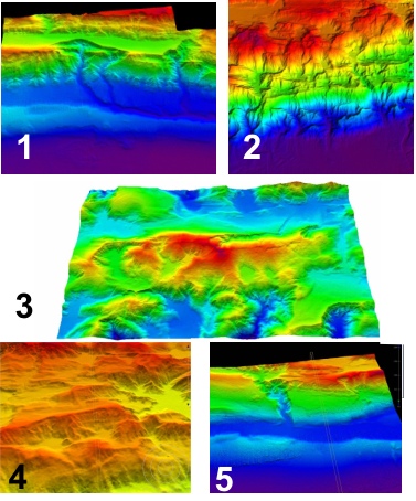 |
Figure 1. | Figure 2. | Figure 3. | Figure 4. | Figure 5. |
Febuary 11, 2005 Bulletin from HMS Scott
There has been some confusion offship of the aims and objectives of the survey, to clarify this we herewith identify the main objectives as were initially identified.
Main objectives:
To acquire high resolution swath bathymetric data over that part of the area of the main fault rupture of the 26th December 2004 earthquake that lies in Indonesian waters.
To seek for and identify evidence of relatively recent seabed movement (slumps, slides, faults and folds) as targets for future study.
To provide baseline data for further studies using other types of equipment.
To test for differences in margin structure and morphology along and across strike.
To investigate for differences in structure in the south of the area across a possible major segment boundary, where the earthquake rupture is believed to have terminated.
Misinterpretations:
The data being collected in the area of the survey may not be of such specific use in the design and location of the proposed tsunami warning system; in particular the siting of seabed monitoring equipment. However the data acquired will ultimately contribute to the hazard assessment and risk mitigation within the region.
HMS Scott onboard scientists
Febuary 10, 2005 Bulletin from HMS Scott
Following the transit back from the forearc basin, we have picked up the survey of the upper part of the accretionary wedge, which will continue in two blocks until we leave the area.
The transits to and from the forearc basin crossed the outer-arc high. The general accretionary wedge fold/fault trend can still be seen in a NW-SE direction. Additionally, discontinuous N-S linear structures, probably representing strike-slip faults, are imaged on the upper accretionary wedge/outer-arc high.
We are trying to do the detailed planning of the exit from the survey region, and our route is currently under discussion. We would very much like to be able to collect data along the lines of existing cable route surveys, but will be unable to do so unless we receive their precise locations soon.
The Scientists.
We are nearing completion of the first block of the upper accretionary wedge coincident with part of the area of high slip distribution outlined by Chen Ji (CalTech). There is strong evidence for numerous phases of tectonic activity and slope failure. The most recent features appear fresh based upon angular morphology, steep slopes and lack of degradation. The high resolution of the system has allowed us to identify discrete bedding planes within exposed slide scars and in the core of plunging folds. In places, a prominent surface layer up to 100 m thick appears particularly competent(e.g., Figure 1). Within the numerous slides scars, small slump features are observed (Figure 2).
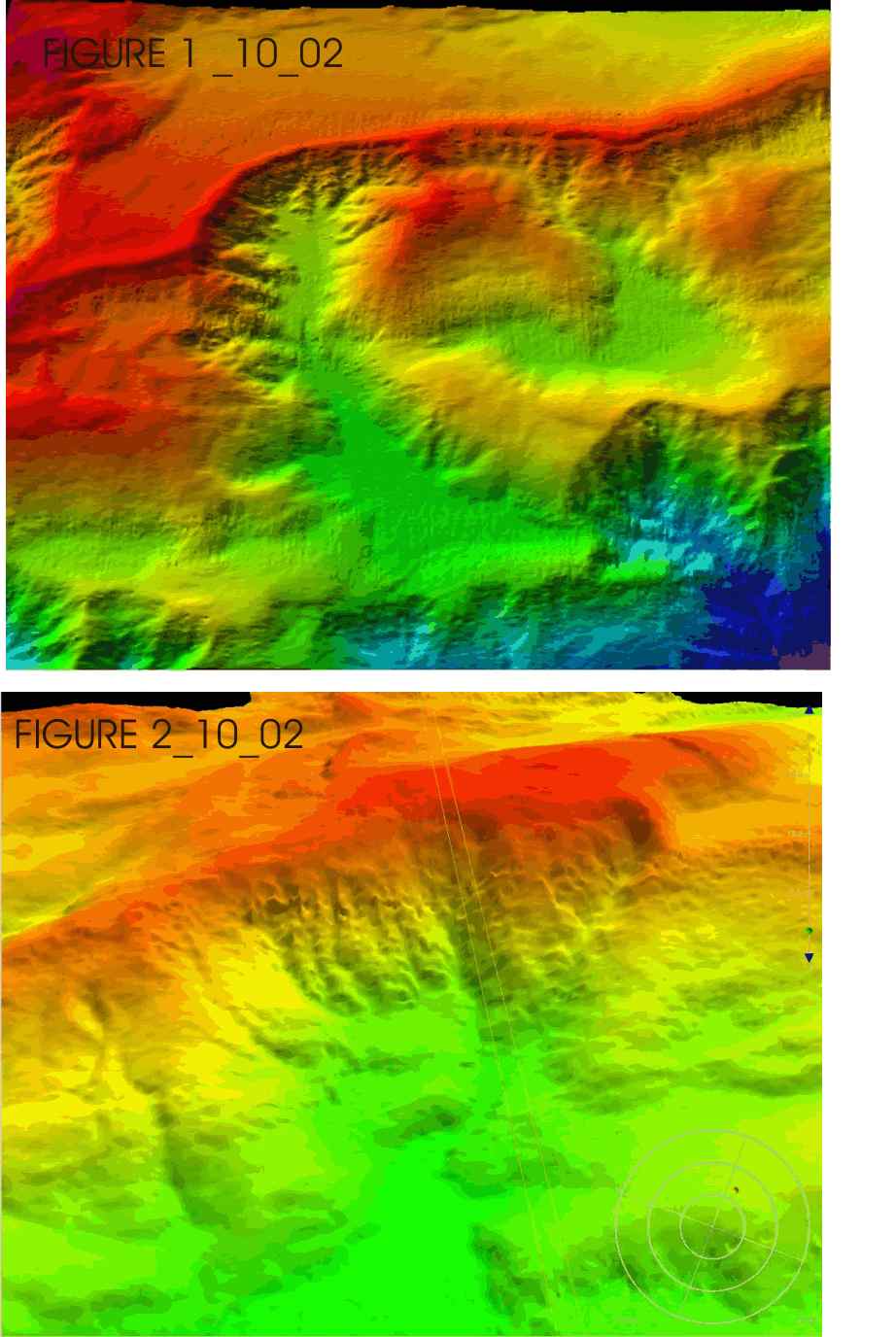 |
Figure 1 - a slide scar with at least two phases of erosion showing the competent surface layer. | Figure 2 - vertical exaggeration approximately 1.5. |
The onboard scientists.
Febuary 8, 2005 Bulletin from HMS Scott
A brief Sitrep only.
We have completed surveying the deformation front have and started to work
on a block which extends our existing data in a block up the main accretionary prism near the middle of the deformation front surveys. This block was selected as a range of landforms and balances between deformation and erosion processes were seen near the deformation front. The embarkation of Indonesian observers and a journalist was accomplished efficiently by transiting to carry out a short investigation of the forearc high and forearc basin. When the journalist departs (expected tomorrow afternoon) we will transit back along a different route and resume surveying the accretionary prism.
A press conference will be taking place on Wednesday 9th February to summarise findings from the first part of the survey.
We have now completed a short survey of the northern part of the forearc basin and its flanks (located 80 km west of Sumatra) between helicopter transfers of our 2 Indonesian observers and 1 journalist.
The shallow gradient eastern basin margin has active well-established canyon systems that feed the forearc basin from the east with no evidence of fault control. The steeper western margin is bound by a clear strike-slip fault system. Neither basin margin shows recent slope failure. The basin floor surveyed is flat and undeformed. In earlier transit from the accretionary wedge across the outer arc high region, the clear NW-SE fold trend is observed with possible evidence of strike-slip faulting.
Febuary 4, 2005 Bulletin from HMS Scott
We are surveying west of the island of Simeulu off Sumatra at the southeastern end of the earthquake rupture zone. This is the first time we have seen land during the survey. There was a noticeable absence of wildlife until recently. But closer to the island, we have now observed a whale, dolphins, flying fish, a swallow and a dragonfly, as well as local fishing vessels.
We have now completed the survey of the deformation front within the Indonesian EEZ and beyond the southern end of the rupture zone. We have selected areas of particular interest to extend the survey further landward across the accretionary wedge and will begin these tomorrow. In the next few days, we plan also to survey part of the forearc basin closer to the island of Sumatra. This region also coincides with a cluster of aftershocks at various depths. We will investigate for evidence of recent large seabed movement, including seabed failures. En route, we will cross the outer arc high which separates the accretionary wedge from the forearc basin. This structure may be fault controlled and is also associated with aftershock activity.
Febuary 2, 2005 Bulletin from HMS Scott
HMS Scott has almost finished collecting the third block of data which will complete the part of the planned bathymetric survey along the deformation front. We are currently collecting data over the segment boundary where the rupture of the earthquake of December 26, 2004, ended, to the south west of the island of Simeulu. We note that the margin surveyed to date has several distinct structural trends from north to south:
- In the north, the margin and its thrust ridges trend approximately 340 for 170km.
- Next going toward the south, trends are more westerly (about 310) for 120km.
- A distinct short section (at the main segment boundary) trending about 280 extends for 40-50km.
- To the south of the segment boundary the trend returns to approximately 310.
The survey of the southern block is expected to end early on 4th February. Following this, we plan to collect a block of data extending further upslope across the accretionary wedge. This is the region of highest slip predicted from the preliminary finite element modelling of Chen Ji (Caltech) and a cluster of aftershocks located by the US NEIC.
Febuary 1, 2005 Bulletin from HMS Scott
HMS Scott, the first survey vessel to reach the area of the 26th December, 2004 Indian Ocean earthquake rupture zone, has collected a block of multibeam bathymetry data. The block covers a region of ~200 km along the deformation front and 30-40 km in width across the accretionary wedge. This is the initial phase of a more extensive ongoing survey within the earthquake zone. The sonar system is intended for deep water but has very high resolution. We see numerous features indicating neotectonic activity and evidence of youthful mass wasting.
The region surveyed can be divided into two main areas based on seafloor morphology. The northern area has coherent fold-thrust ridges which trend towards the NNW and are continuous over as much as 70 km. The youngest ridges are approximately 5-15 km apart, are separated by sediment-filled basins and are typically 500 m high. Each ridge has multiple minor fault scarps or ridges on one or both of the flanks. The thrust ridges have slight changes in orientation and occasional lateral offsets. The southern area is highly dissected with numerous slide scars. In this region, it is difficult to identify coherent thrust ridges. In some cases, ridges appear to have been completely eroded exposing the level ponded basin behind.
Several mechanisms of mass wasting appear to be operating. We summarise their morphological character and possible mechanisms below:
- Sheet-like failures producing large flat blocks up to 2 km in width and 100 m height. These blocks have moved up to 15 km downslope and onto the abyssal plain. In some cases, the absence of dissection of the headwall scarp and the angularity of the blocks suggests they are young in comparison with others. This style of mass wasting is common in the northern area described above.
- Dissected complex slide scars occasionally extending parallel to the ridge axes for many kms, with scalloped headwall scarps. Material from these scars forms fans of unconsolidated sediments, often dissected by feeder channels on the abyssal plain. This style of mass wasting is common in the southern area described above.
- Extreme slumping along the seaward flank of thrust ridges.
This style of mass wasting is common in the northern area described above.
The data allow us to identify numerous small neotectonic features:
- Cumulative scarps of 20 -100 m height
- Trough features of 5 - 30 m depth
- Minor thrust ridges at fold-basin contact illustrating recent activity on otherwise relatively mature and eroded ridges.
Some of these features are small enough to be generated by very few discrete events and minor enough to be quickly filled with sediment or degraded.
The next phase of surveying will continue to the south along the deformation to include the major segment boundary, which marked the southern termination of slip during the recent earthquake. These data may indicate what controls this boundary and will allow us to make comparisons between the part of the margin which ruptured on December 26th and that which did not.
Different techniques which might be used in future surveys, to further constrain the origin of features identified during this survey include, deep-towed sidescan sonar, seismic profiling, ROV surveys, and coring.
This survey will lead to an exceptional increase in the resolution of bathymetric data available, where existing bathymetric data was based on tracklineswith up to 60 km spacing. This is a region where scientific data is limited. Therefore, this is the first time the morphology of the segment of the margin where the recent earthquake occurred has been imaged and investigated. The swath system being used allows an unusually high level of detail fora regional scale survey.
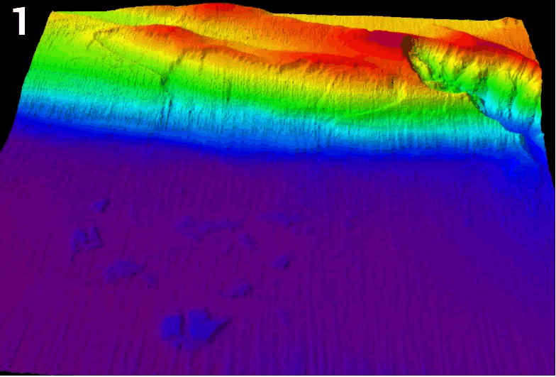 |
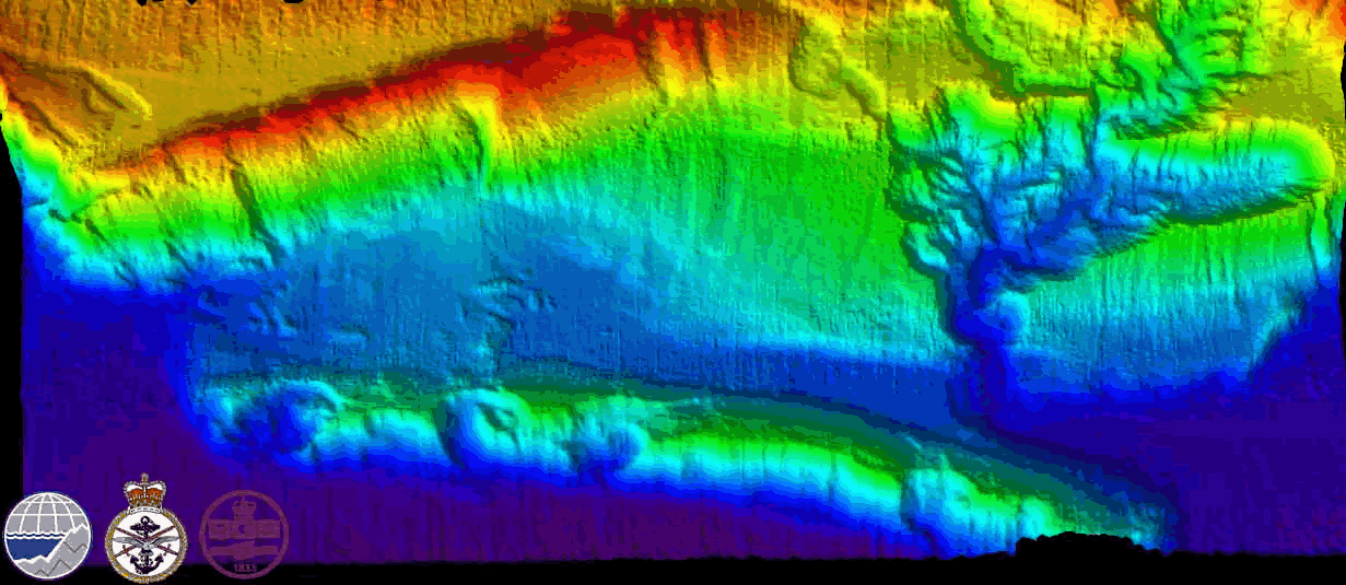
Figure1 Showing a view to the northeast, topography exaggerated by a factor of 2 of large slump blocks (up to 100 m high and 2 kms wide) originating from slide scar in middle distance. Image from the plate boundary (transition from purple to blue). |
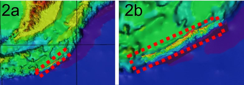
Figures 2a & 2b Comparison of previous GEBCO bathymetry and that obtained during present survey showing large errors in previous datasets. |
 |
January 28, 2005 Bulletin from HMS Scott
We have almost completed acquiring a block of data 200 km in length along the lower part of the accretionary wedge.
We have observed numerous slide scars and slumps of varied scales and ages. Many canyons cross-cut the lowermost NNW-trending thrust ridges.
Figure 1. Slide scars at the base of the Sumatran margin where the two plates are colliding. View to the east and ~40 km across. |
 |
 |
Figure 2. Slide scar complex 10 km across at the base of the accretionary wedge, to left of image. Multiple minor thrust ridges can be seen in the foreground. View to the east and 30 km across. Topography is exaggerated by a factor of 2.5 |
January 27, 2005 Bulletin from HMS Scott
The British ship HMS Scott arrived in Indonesian waters on 25 January 2005, where for the next few weeks she will carry out a swathe bathymetry survey of the sea bed near the epicentre of the earthquake which struck Aceh and North Sumatra on 26 December. See also http://www.operations.mod.uk/garron/index.htm.
Scientists from the British Geological Survey and Southampton Oceanography Centre are onboard. This is the first Marine Scientific Research task conducted by HMS Scott.
The survey aims to provide a multibeam survey of the area that could be used as a base map for future detailed surveys. It is anticipated to extend from the base of slope to the outer arc high and will examine the sea bed morphology for possible fault activity and evidence of mass movement.
Report from Dave Tappin (BGS) at 8:00 UTC 26/01/2005
"We are now at the north end of the Malacca Strait, about to start acquiring data over a couple of reported shallow spots in this area, affectionately termed the 'Mythical Mounds'. Once we have determined their absence/presence we will steam northeast and acquire data along a NE-SW track in the area just to the south of the Indian/Indonesian Median Line. This should take about 12 hours. Thereafter we will survey along the subduction zone boundary in deep water to identify any dislocations that exists along the inner trench wall."
Christian K Wilson
British Geological Survey
Murchison House
West Mains Road
EDINBURGH
EH9 3LA
Tel direct: - +44 131 650 0355
Tel main: - +44 131 667 1000
e-mail: ckw@bgs.ac.uk