| Distribution of the Minimum Transmissivity | |
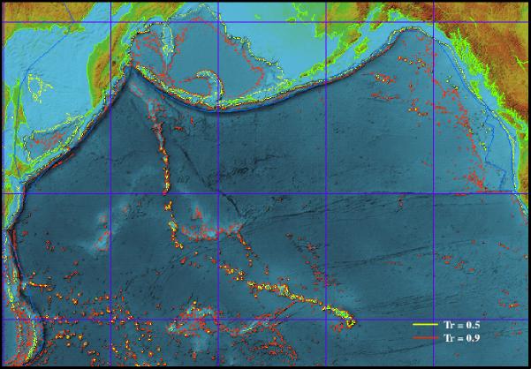 |
Minimum transmissivity is given by: Tmin = 2e / ( 1 + e 2 ) where e =  (h/H) (h/H)Depends only on the depth h of the topographic feature and the depth H of the surrounding water |
| H = 5500 m | |
North Pacific Conclusions |
| • The shorter-scale topography between the Alaska-Aleutian Subduction Zone and Hawaii does not attenuate tsunami waves significantly • The Emperor Seamount Chain, Hawaiian Ridge, and Mid-Pacific Mountains interact strongly with tsunami waves, reflecting them and forming narrow bands of higher/lower tsunami wave amplitudes extending well-beyond these features • The Hess Rise, Northwest Hawaiian Ridge, Shatsky Ridge and Musician Seamounts also produce some tsunami wave scattering and refraction • Using smoothed topography in numerical models produces excessive leakage into the back-basins behind island-arc source regions (into the Bering Sea from the Aleutian Islands, into the Sea of Okhotsk from the Kuril Islands), as well as through the Emperor Seamount Chain and the Hawaiian Ridge |
General Conclusions |
| • Differential scattering along oceanic ridges and seamount chains can lead to narrow bands of higher/lower tsunami wave amplitudes that extend well-away from these features • The depth parameter e and minimum transmissivity Tmin are useful tools for identifying topographic features that cause substantial tsunami wave reflection and scattering • Troughs have much less effect on tsunami waves than topographic highs • Smoothing or subsampling topographic features can cause numerical models to overestimate the transmission of tsunami waves past these features |
References |
| Carrier, G.F., 1971, The dynamics of tsunamis, in Mathematical Problems in the Geophysical Sciences, 1. Geophysical Fluid Dynamics (W.H. Reid, ed.), Amer. Math. Soc., Rhode Island, 157-187. Koshimura, S., F. Imamura and N. Shuto, 1999, Propagation of obliquely incident tsunamis over a continental shelf and an oceanic ridge, Coastal Engineering Journal, in press. Meyer, R.E., 1995, On the interaction of water waves with islands, in Long-Wave Runup Models (H. Yeh, P. Liu, C. Synolakis, eds.), World Scientific, New Jersey, 3-24. Smith, W.H.F., and D.T. Sandwell, 1997, Global sea floor topography from satellite altimetry and ship depth soundings, Science, 277, 1956-1962. Titov, V.V., H.O. Mofjeld, F.I. González and J.C. Newman, 1999, Offshore forecasting of Alaska-Aleutian Subduction Zone tsunamis in Hawaii, NOAA Tech. Memo. ERL PMEL-114, 22 pp. |
 |